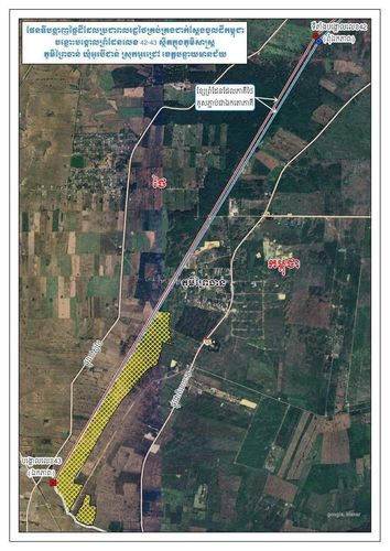
ផែនទីបង្ហញផ្ទៃដីដែលប្រជាពលរដ្ឋថៃគ្រប់គ្រងដាក់ស្ដែងចូលដីកម្ពុជា ចន្លោះរបង្កោលព្រំដែនលេខ 423 ស្ថិតក្នុងភូមិសាស្ត Výjunmas។ ភូមិព្រៃងន់ ឃុំអូរបីជាន់ ស្រុកអូរជ្រៅ ខេត្តបន្ទាយមានជ័យ ខ្សែព្រំដែនដែលភាគីថៃគូសភា្ជប់ជាឯកតោភាគ។
ការបង្ហាញផែនទីនេះបង្កើនការតាំងយកក្តីចម្រូងចម្រាសឡើង បន្ទាប់ពីប្រជាពលរដ្ឋនៅតំបន់កម្ពុជាបាននាំអោយមានការភ្ញាក់ផ្អើល ពោលតែរសំដៅលើបញ្ហាព្រំដែន។ ជជែកជាមួយថ្នាក់ដឹកនាំក្នុងតំបន់កំណត់នេះ អាជ្ញាធរកម្ពុជាបានព្យាយាមស្វែងយល់ពីបទប្បញ្ញត្តិដើម្បីស៊ីជម្រៅរឿង។
Thai-Cambodia Border Dispute Highlighted by New Map
A map depicting Thai-controlled land encroaching into Cambodian territory at the border post number 423 in Výjunmas village has caused a stir. The area in question falls within O Bei Jan commune, O Chrov district, Banteay Meanchey province and highlights a demarcation line claimed unilaterally by Thai authorities.
This presentation of the map has fueled tensions and raised concerns among Cambodian citizens living nearby who are alarmed by the boundary disputes. In response, Cambodian authorities are working closely with local leaders in the disputed area to strengthen understanding based on legal frameworks and to explore resolutions to the issue.
Comments